Off-road Northern Vietnam Maps 2023 (With Routes)
If you are passionate about traveling Vietnam by motorcycle, North Vietnam undoubtedly offers some of the most challenging routes that you have heard of. This article recommends the top four off-road Northern Vietnam maps with routes you might want to consider when joining a Vietnam motorcycle tour through this area.
Northern Vietnam Overview
Referring to Northern Vietnam is to mention the majestic and misty mountains, the cloud-covered passes, the magnificent terraced fields, the forests of ban flowers, peach blossoms, apricot flowers, and the bright smiles of innocent ethnic children. All blend together to create an extremely attractive Northwest that draws local and foreign travelers each year. Northern food has its own distinct and appealing characteristics too. Simple elements from the nearby mountains are frequently used in the cuisine here along with unique processing methods, many dishes in this mountainous area have become famous and are specialties that anyone who comes here should taste once such as Dried Buffalo Meat, Thang Co Ngua, Lon Cap Nach, Tao Meo Wine,…
Along with the awesome natural surroundings, the traditional culture of the ethnic groups is an appealing tourism potential for tourists who enjoy exploring and experiencing too. Many ethnic communities live in Northern Vietnam, including Tay, Nung, Thai, Muong, Mong, Dao, and others. Many ethnic groups maintain their traditional cultural identity through customs and practices, festivals, costumes, musical instruments, and folk songs, such as the Long Tong festival and the Khau Vai Market, as well as through community behavior, house architecture, and market with diverse and large cultural spaces.
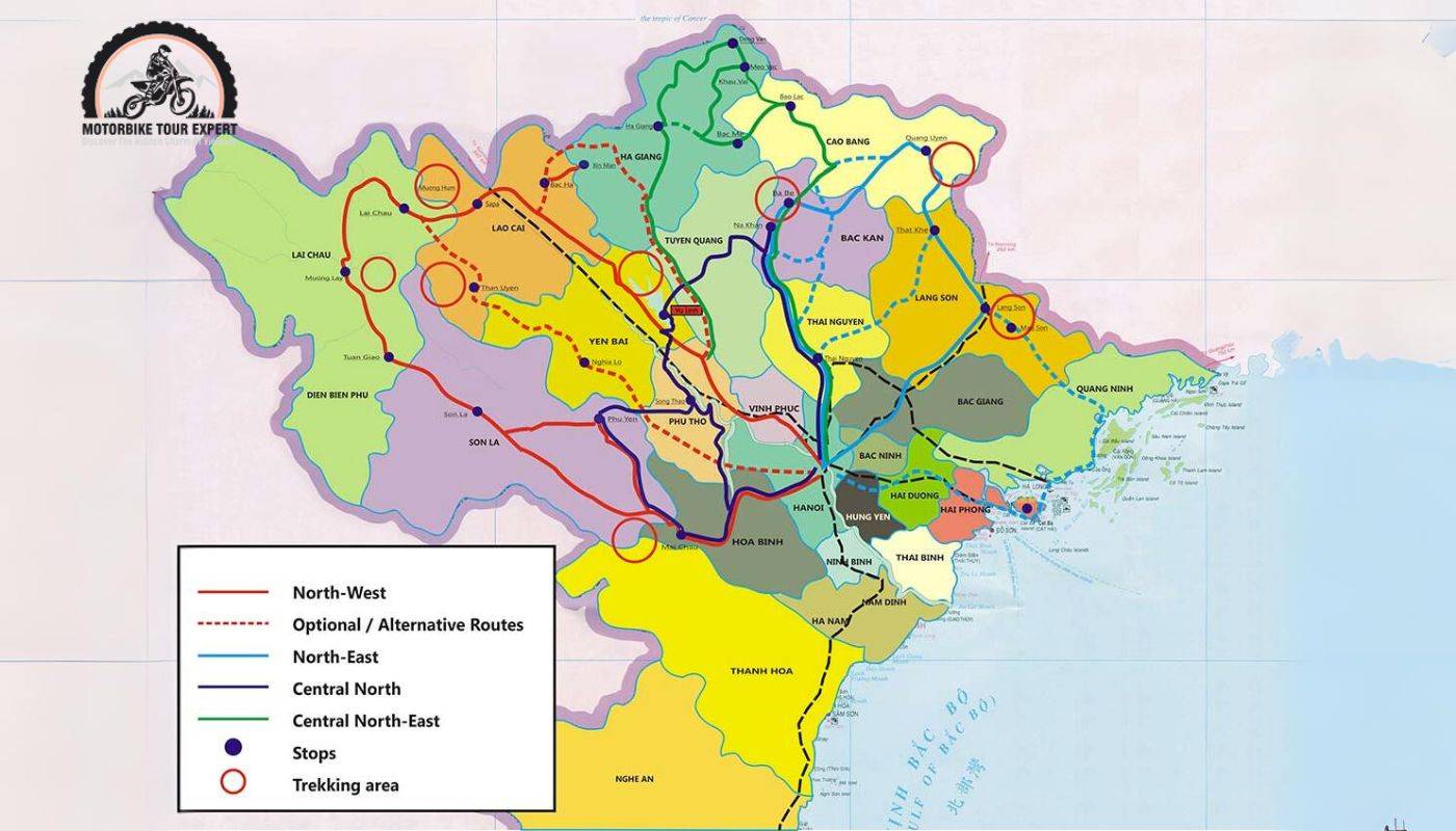
Off-road Northern Vietnam Maps Overview
The northern region offers some of the most significant motorcycle opportunities better than anywhere in entire Vietnam. It not only has the most spectacular landscape on a grand scale but also taller mountains and greater passes. Riding can be slow and occasionally dangerous owing to landslides, floods, mud, and terrible road conditions. Still, this is a passionate road that any riders want to conquer because of the breathtaking scenery, the spectacular roads, and the intriguing history and culture of many ethnic communities.
With so many gorgeous roads and iconic sights along the way, picking an optimum route and seeing them all is tough. As a result, establishing the time, travel itinerary, and cost that depends on your own preference is crucial. Here are the top four off-road Northern Vietnam Maps with routes you might consider before joinning Northern Vietnam Motorbike Tours.
Off-road Northern Vietnam Maps Overview
Top 4 off-road Northern Vietnam Tours Map
Hanoi – Mai Chau – Pu Luong Route
This off-road Northern Vietnam Maps with routes takes in some of the most beautiful landscapes in the country and visits some of the most isolated places along the border with Laos. Mai Chau is the first stop on this loop. Mai Chau is located around 150 kilometers northwest of Hanoi. With mostly steep terrain, Mai Chau is a remote and potentially risky destination for motorbike tourists. Throughout the route, you will encounter several lengthy slopes and passes, including Cun Slope, Thung Khe Pass, and Mai Chau Pass,… If you leave early in the morning or late at night, drive carefully to ensure your safety because fog is strong at these times, which will reduce visibility while driving. While at Mai Chau, don’t miss out on visiting Lac village, which has been embedded in Thai cultural identity for 700 years. Terraced fields interlaced with small villages also provide a nicely tranquil, rustic, and charming landscape.
The next stop is Pu Luong – about 70 kilometers from Mai Chau. This place is well-known for its natural scenery and fresh air blended with golden terraced fields during the rice season. There are numerous rocky passes on the way from Mai Chau to Pu Luong, and some portions follow the Ho Chi Minh Trail – a historic path from the Vietnam War. When visiting Pu Luong, do not forget to explore Ban Don, Ban Kho Muong, which has stilt dwellings and expansive rice fields, or Pu Luong Peak – an ideal peak for people who enjoy trekking.
Sa Pa – Ha Giang Route
Despite the spectacular and overwhelming natural scenery, the 200-kilometer journey from Sa Pa to Ha Giang remains a hardship for many motorbike travelers. This Off-road Northern Vietnam Maps with routes features several passes, continuous hills, and zigzags, as well as generally harsh weather conditions and heavy fog in the morning and evening. As a result, it is vital to equip yourself with safety gear and to regularly service your motorcycle before riding. Here is the recommended route that you can consider: Bac Ha – Xin Man – Hoang Su Phi – Ha Giang – Dong Van – Meo Vac.
When coming to Sa Pa, don’t forget to visit Cat Cat village – a beautiful simple village of the Northwest with the H’Mong wooden houses weaving between the Muong Hoa valley along with small streams, beautiful fields, and colorful brocade costumes. Cloud hunting at the top of Fansipan is also an outstanding activity that you can participate in. As for Ha Giang, conquering Ma Pi Leng pass or Lung Cu flagpole – the northern highest point of Vietnam or exploring Yen Minh pine forest and Dong Van Rock Plateau in Dong Van motorbike tours are things you should not miss when coming here.
Bac Kan – Cao Bang – Lang Son Route – Beautiful Off-road Northern Vietnam Maps with route
Cao Bang is a mountainous province located in the Northeast region of Vietnam, with a border of more than 300 km long bordering China. The road from Bac Kan to Cao Bang is about 115 km long, the road conditions are relatively good, small but flat, though there are many consecutive turns, especially after passing through the Ngan Son area. Therefore, be careful when driving through these sections. Preparing warm clothes and bringing a raincoat is also essential because the temperature in Cao Bang mountains can drop to 15-16 degrees Celsius in the early morning and evening.
Travelers may start their journey in Bac Kan by visiting Ba Be National Park, a primeval forest that protects thousands of distinctive plant and animal genetic resources. Furthermore, in the heart of this national park sits Ba Be Lake, one of the world’s 20 most magnificent natural freshwater lakes that must be preserved. When visiting Cao Bang, take advantage of the opportunity to conquer the Ban Gioc Waterfall path, including crossing Ma Phuc Pass and Khau Lieu Pass.
From Cao Bang to Lang Son, you will also experience passing isolated areas of thick jungles, rivers, and seemingly endless mountains. There is a network of back roads winding and turning through a very lush scenery of rivers, jungles, and hills. All of the back roads are now paved, however, their quality fluctuates at times, and because the terrain is so rocky, the roads are at risk of landslides after heavy rain. In good weather, though, you might enjoy these picturesque routes.
Lao Cai – Lai Chau – Dien Bien Route – Magnificent Off-road Northern Vietnam Maps with route
This is most likely the most isolated route on the whole Northern off-road motorcycle tour map. This route surpasses both China and Laos and passes across enormous territories, many of which are quite sensitive so be careful when driving through these areas. Besides, extreme mountains, off-the-beaten-path, and tortuous roads exist between Lao Cai and Dien Bien Phu. As the roads are so hilly, they are often at high risk of landslides, especially after heavy rains, making them inaccessible for hours or even days. March to May and September to October are the ideal time to travel on this route.
When visiting Lao Cai, you should not miss Y Ty commune and Sa Pa city. The huge terraced fields of Y Ty, golden in the ripe rice season, or the wild primeval forests and ancient minorities villages of Sa Pa, located at a height of 1500 – 2000 m above sea level, have long been a famous tourist destination. In addition, during the winter season of December, Lao Cai seems to put on a new, mysterious yet charming look – which will definitely take your breath away.
O Quy Ho Pass, a nearly 50-kilometer-long pass between Lao Cao and Lai Chau, is also an essential transportation route that you might want to cross. Winding over the Hoang Lien Son range, past Fansipan peak – the roof of Indochina at 3414 m – promises to be a spectacular experience for travelers. Furthermore, when you arrive in Dien Bien, you will be able to admire the majesty of the magnificent high mountains and conquer the Zero Milestones on the summit of Pa A Chai – which links Vietnam’s border with Laos and Cambodia.
In conclusion, there are many challenging routes and famous places to visit on the off-road Northern Vietnam maps with routes. Choosing an appropriate route is entirely dependent on each individual’s particular tastes and needs. As a result, before each trip, we recommend that you should actively research and prepare a detailed plan. This not only provides comfort and safety during the whole journey but also brings the most full-filled and unforgettable experience when joining an off-road motorbike tour.